Alfred Russel Wallace
oceanography
biogeography

|
Wallace line
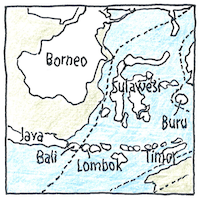
Alfred Russel Wallace drew a line east of Bali, east of Borneo, east of Java, marking the separation from Australia of animals from Asia. West of his line, during the farthest glacial advances, ocean levels were 390 feet lower, connecting the islands on the Sunda Shelf to the Asian mainland, but deep water along the Wallace line separated tigers from koalas and kangeroos.
Wallacea
Islands persisted east of the Wallace line even when the oceans were at their lowest, separated both from Asia and from the Sahul Shelf that surrouds Australia and connects Australia across the Arafura Sea to New Guinea. The islands of Sulawesi, Maluku, Halmahera, Seram, Buru, Lombok, Sumbawa, Sumba, Komodo, Flores, Nusa Tenggara Barat, Nusa Tenggara Timur, Timor, Sumba, Wetar, and hundreds of other islands remained separate from both Asia and Australia.
Crossing waters
The sweet potato spread across the Pacific without the benefit of boats. Not so the koala, who hugs its gum tree, or the kangaroo, who hops and swims but would not cross the Wallace line. Why do some animals cross the water? Why do some think better? Many birds migrate across oceans but some are more like me, preferring smaller and safer waters.


Wallace’s line defines the north-western boundary of Wallacea; Lydekker’s line defines the south-eastern boundary. Then there’s Webber’s line, which parallels Lydekker’s line and provides an alternative to Wallace’s line, below which the mammalian fauna is exclusively Australasian.
See also in The book of science:
Readings in wikipedia:
Other readings: